How to Use DBF Files in ArcGIS and Convert Shapefiles to GeoJSON or KML
A DBF file opened alone in ArcGIS Pro shows up as a table in the Contents pane – rows, columns, ready to browse or query. The map view stays empty. This is the standard behavior for an ArcGIS DBF file: attribute values like names, categories, and measurements fill the table, and a DBF simply never carries the coordinates a map needs to plot anything.
What a DBF File Contains in an ArcGIS Shapefile
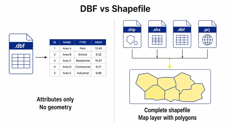
A shapefile isn't one file. It's a small group of files that work together, and ArcGIS needs several of them present to function correctly.
- The .shp file stores the geometry – the actual points, lines, or polygons.
- The .shx file stores an index into that geometry, letting ArcGIS locate individual shapes quickly.
- The .dbf file stores the attribute table: field values tied to each shape by record order.
- The .prj file, when present, defines the coordinate reference system the geometry is measured in.
This is the core of the shapefile components .shp .shx .dbf setup, and a DBF shapefile only functions as a spatial layer when the .shp and .shx are sitting right alongside the .dbf. Remove either one, and ArcGIS has nothing to draw, regardless of how complete the attribute table looks.
How to Import an ArcGIS DBF File
Getting a DBF file ArcGIS import right depends on what the goal actually is: a plain table, or a full spatial layer.
Add a Standalone DBF Table
Add Data > browsing to the .dbf file directly loads it as a table in the Contents pane. DBF ArcGIS imports done this way carry no geometry, no symbology, nothing rendered on the map – just rows that can be queried, joined to a spatial layer by a shared field, or exported later.
Open DBF Attributes with SHP and SHX Files
Adding the .shp file instead of the .dbf pulls in the complete shapefile. ArcGIS reads the .shx for the geometry index and the .dbf for attributes automatically, all in one step. This is the only route to seeing actual geometry on the map. There's no tool covering how to convert DBF to shapefile in ArcGIS, because a standalone DBF was never missing a conversion step – it was missing coordinate data from the start, data that has to come from somewhere else entirely.
How to Export a DBF Attribute Table from ArcGIS
Exporting an attribute table is a separate operation from exporting geometry. Right-clicking the layer or standalone table in the Contents pane, then choosing Data > Export Table, brings up a dialog for picking the output format – a .dbf, a .csv, or a table inside a geodatabase. Going the DBF to CSV ArcGIS route works well when the destination is a spreadsheet tool or another non-spatial system that doesn't need ArcGIS installed at all.
Field names sometimes shift during this process. Geodatabase field names can run well past 10 characters, but the DBF format caps names at exactly that length, so ArcGIS truncates and often appends a number to keep each name unique. Checking the output field list against the source table catches this before anyone downstream notices values under the wrong header.
Once the table is exported, confirming it independently is worth the extra minute. DBF Viewer 2000 opens the resulting .dbf file directly, without needing ArcGIS running at all – record counts, field types, and character encoding are all visible immediately, which matters before sharing the file with someone who doesn't have GIS software or before feeding it into another process.
Can You Convert DBF to GeoJSON in ArcGIS?
A standalone DBF, on its own, can't become GeoJSON. GeoJSON format requires geometry, and a plain attribute table has none to offer. Converting DBF to GeoJSON only works starting from the full shapefile, or from a DBF whose fields hold coordinate values that ArcGIS can turn into points.
Export a Shapefile Layer as GeoJSON
The Features To JSON tool, found in the Conversion Tools toolbox, handles this conversion. Running it against a shapefile layer, with the output format parameter set to GeoJSON rather than Esri JSON, carries both geometry and attributes into the result – DBF fields become GeoJSON properties, one per feature. Running the same tool against a standalone DBF table, with no shapefile geometry attached, either fails outright or produces plain JSON with no coordinates at all, since DBF to GeoJSON conversion depends entirely on geometry that a bare table simply doesn't carry.
How to Convert DBF and Shapefile Data to KML
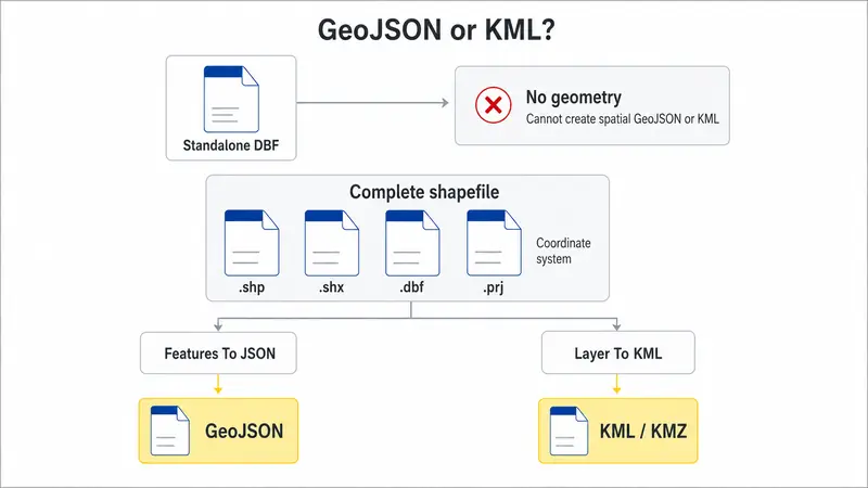
The Layer To KML tool takes a shapefile layer – not a bare DBF table – and produces a .kmz file, carrying attribute fields into KML's ExtendedData tags along with the geometry. Running a DBF to KML conversion this way means each shape ends up in the output with its attributes attached, viewable in Google Earth or any KML-compatible viewer.
Coordinate systems matter here. KML expects WGS84 coordinates natively, so Layer To KML reprojects automatically, regardless of what coordinate system the source shapefile was built in. That reprojection depends on a valid .prj file being present. A missing or corrupted .prj can throw off the output silently, placing features in the wrong location without any error message – worth checking before running the tool, not after seeing shapes land somewhere unexpected on the globe.
A DBF table and a spatial layer solve different problems. Working with a plain DBF means working with attributes only – no shapes, no coordinates, nothing to render on a map. Converting to GeoJSON or KML means starting from a complete shapefile, or building geometry from coordinate fields that a bare DBF happens to contain. Keeping that distinction in mind before opening ArcGIS saves time re-importing files that were never going to show geometry in the first place.
Frequently Asked Questions for ArcGIS system
What happens if the SHX file is missing from a shapefile?
ArcGIS can't draw the layer without it. Some versions generate a temporary index automatically, but that's not reliable for ongoing work – restoring the original .shx file is the safer fix.
Why are DBF field names truncated in ArcGIS?
DBF format caps field names at 10 characters, a limit inherited from the original dBASE III specification. Longer geodatabase names get cut and often suffixed with a number to stay unique.
Can you edit a shapefile DBF without damaging the geometry?
Editing attribute values through ArcGIS generally leaves the geometry alone. Deleting rows or changing field types outside ArcGIS, with a different tool, risks desynchronizing the .dbf from the .shp and .shx.
Why do special characters display incorrectly after importing a DBF file?
A code page mismatch between how the DBF was originally saved and how ArcGIS interprets the encoding usually causes this. Checking the source file's encoding before import resolves it.